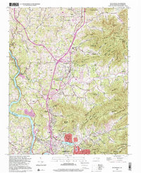
1997 Map of Weaverville
USGS Topo · Published 2001About this map
The French Broad River carves the western edge of this Buncombe County landscape, where the towns of Weaverville, Woodfin, and northern Asheville reflect the post-war growth of the Blue Ridge foothills. Compiled from imagery updated in the late 1990s, the map illustrates a complex network of mountain ridges and gaps, notably Brittain Mountain and Elk Wallow Gap, that dictated the path of early settlements and modern infrastructure. Cultural landmarks such as the Asheville Weaverville Speedway and Craggy Prison appear alongside older community anchors like Alexander Chapel and the Sheppard Cem. Transportation history is evident in the Norfolk Southern rail line following the river's bend and the high-elevation route of the Blue Ridge Scenic Highway traversing the southern peaks near Pleasant Knob. This edition captures the area's transition into a more suburbanized corridor while maintaining the namesake "coves" and family-named landmarks like Thurz Knob and Reynolds Mountain.
Find a feature on this map
67 named features on this map. Tap any name to fly to it.
Don’t see what you’re looking for? This feature index may not catch every label — zoom into the map to look around manually.
Map Details
Editions of this 1997 Weaverville Map
This is the sole edition of this map. No revisions or reprints were ever made.
Other maps of this area

1894 · Asheville
USGS Topo · 1:125,000

1900 · Mount Mitchell
USGS Topo · 1:125,000

1901 · Asheville
USGS Topo · 1:125,000

1902 · Mount Mitchell
USGS Topo · 1:125,000

1935 · Barnardsville
USGS Topo · 1:24,000

1935 · Craggy Pinnacle
USGS Topo · 1:24,000

1936 · Marshall
USGS Topo · 1:24,000

1936 · Enka
USGS Topo · 1:24,000

1936 · Weaverville
USGS Topo · 1:24,000

1936 · Mars Hill
USGS Topo · 1:24,000