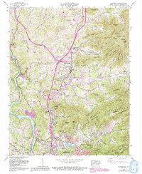
1962 Map of Weaverville
USGS Topo · Published 1993About this map
Weaverville and the northern outskirts of Asheville define this landscape along the French Broad River during a period of significant suburban growth. The presence of the Asheville-Weaverville Speedway and the Beaver Lake Golf Course reflects the area's mid-century recreational development. In the highlands, legacy family names persist in landmarks like Lankford Mountain and Brittain Mountain, while small community centers are marked by numerous houses of worship, including Clarks Chapel, Salem Ch, and Mt Bethel Ch. The transportation network is anchored by the Blue Ridge Parkway and the Scenic Highway, which navigate the steep topography of the Swannanoa Mountains to the east. Modern additions captured in purple revision show the expansion of Woodfin and Stocksville as they grew toward the burgeoning county seat.
Find a feature on this map
73 named features on this map. Tap any name to fly to it.
Don’t see what you’re looking for? This feature index may not catch every label — zoom into the map to look around manually.
Map Details
Editions of this 1962 Weaverville Map
3 editions found
Other maps of this area

1894 · Asheville
USGS Topo · 1:125,000

1900 · Mount Mitchell
USGS Topo · 1:125,000

1901 · Asheville
USGS Topo · 1:125,000

1902 · Mount Mitchell
USGS Topo · 1:125,000

1935 · Barnardsville
USGS Topo · 1:24,000

1935 · Craggy Pinnacle
USGS Topo · 1:24,000

1936 · Marshall
USGS Topo · 1:24,000

1936 · Enka
USGS Topo · 1:24,000

1936 · Weaverville
USGS Topo · 1:24,000

1936 · Mars Hill
USGS Topo · 1:24,000