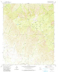
1972 Map of Webb Peak
USGS Topo · Published 1991About this map
The Pinaleno Mountains dominate this high-elevation survey of Graham County, centered on the summit of Webb Peak and its Lookout Tower. The landscape of the Coronado National Forest is defined by a dense network of water sources and recreational sites, from Riggs Lake and the Riggs Flat Recreation Area to more remote locations like Ash Creek Falls and Emerald Spring. Evidence of early industry and infrastructure remains visible at the Mt Graham Mill Site and the ruins of Carter Sawmill.
Find a feature on this map
68 named features on this map. Tap any name to fly to it.
Don’t see what you’re looking for? This feature index may not catch every label — zoom into the map to look around manually.
Map Details
Editions of this 1972 Webb Peak Map
4 editions found
Other maps of this area

1940 · Sierra Bonita Ranch
USGS Topo · 1:62,500

1942 · Sierra Bonita Ranch
USGS Topo · 1:62,500

1942 · Mt. Graham
USGS Topo · 1:62,500

1943 · Sierra Bonita Ranch
USGS Topo · 1:62,500

1944 · Jackson Mtn.
USGS Topo · 1:62,500

1945 · Mt. Graham
USGS Topo · 1:62,500

1946 · Jackson Mtn.
USGS Topo · 1:62,500

1954 · Silver City
USGS Topo · 1:250,000

1956 · Tucson
USGS Topo · 1:250,000

1958 · Silver City
USGS Topo · 1:250,000