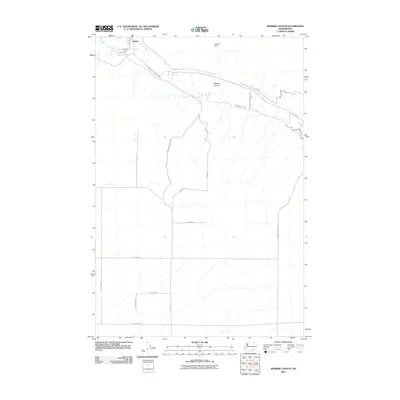
2011 Map of Webber Canyon
USGS Topo · Published 2011About this map
Kiona sits at the northern edge of this agricultural landscape, where the terrain transitions from the lowlands near the river toward the rising slopes of Goose Hill. The geography is defined by the winding path of Webber Canyon and the engineered water systems essential to the region's productivity, including the Kennewick Main Canal and the West Badger Lateral. A systematic grid of rural roads, such as Beightol Rd, Travis Rd, and Krammer Rd, illustrates the parceling of land for farming and ranching south of the Yakima River. This 2011 survey captures the area's developed irrigation infrastructure and the persistent rural character of Benton County, marked by long-standing landmarks like Cemetery Rd.
Find a feature on this map
24 named features on this map. Tap any name to fly to it.
Don’t see what you’re looking for? This feature index may not catch every label — zoom into the map to look around manually.
Map Details
Editions of this 2011 Webber Canyon Map
This is the sole edition of this map. No revisions or reprints were ever made.
Other maps of this area

1915 · Prosser
USGS Topo · 1:125,000

1917 · Pasco
USGS Topo · 1:125,000

1917 · Prosser
USGS Topo · 1:125,000

1951 · Richland
USGS Topo · 1:62,500

1951 · Corral Canyon
USGS Topo · 1:62,500

1953 · Walla Walla
USGS Topo · 1:250,000

1958 · Walla Walla
USGS Topo · 1:250,000

1965 · Whitstran
USGS Topo · 1:62,500
1965 · Prior Ranch
USGS Topo · 1:24,000
1965 · Whitstran SE
USGS Topo · 1:24,000