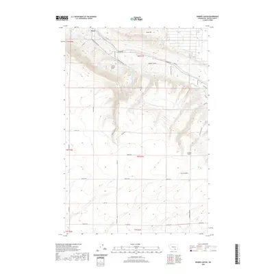
2020 Map of Webber Canyon
USGS Topo · Published 2020About this map
Kiona sits at the northern edge of this landscape, where the plateau of the Horse Heaven Hills begins its descent toward the valley. The topography is defined by significant drainages including Webber Canyon, Scouten Canyon, and Carter Canyon, which carve through the arid uplands of Benton County. Water management is a central theme of the land use here, evidenced by the Kennewick Main Canal and the W Badger Lateral cutting across the northeastern sections to support agricultural development. A network of rural roads such as Beightol Rd and Clodius Rd grid the high country, connecting isolated farmsteads and agricultural plots. The inclusion of Cemetery Rd suggests established community centers and local family heritage sites situated amongst the high ridges and deep coulees of this distinctive Washington terrain.
Find a feature on this map
39 named features on this map. Tap any name to fly to it.
Don’t see what you’re looking for? This feature index may not catch every label — zoom into the map to look around manually.
Map Details
Editions of this 2020 Webber Canyon Map
This is the sole edition of this map. No revisions or reprints were ever made.
Other maps of this area

1915 · Prosser
USGS Topo · 1:125,000

1917 · Pasco
USGS Topo · 1:125,000

1917 · Prosser
USGS Topo · 1:125,000

1951 · Richland
USGS Topo · 1:62,500

1951 · Corral Canyon
USGS Topo · 1:62,500

1953 · Walla Walla
USGS Topo · 1:250,000

1958 · Walla Walla
USGS Topo · 1:250,000

1965 · Whitstran
USGS Topo · 1:62,500
1965 · Prior Ranch
USGS Topo · 1:24,000
1965 · Whitstran SE
USGS Topo · 1:24,000