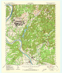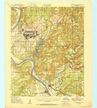
1950 Map of Webbers Falls
USGS Topo · Published 1950About this map
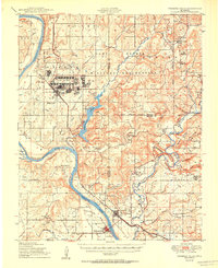
Camp Gruber Military Reservation dominates the northern landscape of this post-war Oklahoma survey, featuring extensive Rifle Ranges and a dedicated Landing Field. The map records a transition point in the region's geography, showing Greenleaf Lake and the winding course of the Arkansas River before major navigational changes. The cultural landscape is notably defined by indigenous history, evidenced by the Red Bird Smith Indian Monument and educational sites like the Sour John Indian Sch and Red Bird Smith Indian Sch. Further south, the town of Webbers Falls sits near the confluence of the Illinois River, serving as a focal point for a rural network of small schools such as Buckhorn Sch and Cedar Creek Sch, alongside the Missouri Pacific railroad corridor passing through Braggs.
Find a feature on this map
69 named features on this map. Tap any name to fly to it.
Don’t see what you’re looking for? This feature index may not catch every label — zoom into the map to look around manually.
Map Details
Editions of this 1950 Webbers Falls Map
2 editions found
Historical Maps of Gore Through Time
8 maps found