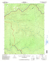
1995 Map of Webster Springs SE
USGS Topo · Published 1998About this map
The Monongahela National Forest dominates this landscape, where the Williams River and Cranberry River carve deep drainages through Pocahontas and Webster Counties. This 1990s record of the high Alleghenies emphasizes the protected solitude of the Cranberry Wilderness, a primitive area defined by its lack of roads and its dense network of footpaths like the North South Trail and Middle Fork Trail. Elevations shift from the high summits of Glade Mountain and Sugar Creek Mountain down to the distinct terrain of the Little Levels and the Edray District. Notable local watercourse names, such as Hell for Certain Branch and Bannock Shoals, reflect the region's cultural geography and the difficulty of its river-bottom travel. The map serves as a vital guide for tracing the historic backcountry boundaries between counties and districts in this high-altitude wilderness.
Find a feature on this map
47 named features on this map. Tap any name to fly to it.
Don’t see what you’re looking for? This feature index may not catch every label — zoom into the map to look around manually.
Map Details
Editions of this 1995 Webster Springs SE Map
This is the sole edition of this map. No revisions or reprints were ever made.
Other maps of this area

1891 · Huntersville
USGS Topo · 1:125,000

1894 · Huntersville
USGS Topo · 1:125,000

1915 · Webster Springs
USGS Topo · 1:48,000

1918 · Webster Springs
USGS Topo · 1:62,500

1923 · Lobelia
USGS Topo · 1:48,000

1923 · Marlinton
USGS Topo · 1:48,000

1923 · Mingo
USGS Topo · 1:48,000

1925 · Mingo
USGS Topo · 1:62,500

1925 · Marlinton
USGS Topo · 1:62,500

1925 · Lobelia
USGS Topo · 1:62,500