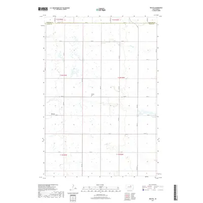
2017 Map of Wecota
USGS Topo · Published 2017About this map
Wecota anchors this section of the prairie, situated at the junction of 153rd St and 354th Ave. The landscape here is defined by a dense network of small depressions and seasonal water bodies typical of the Dakotas, punctuated by the more permanent waters of Lake Cresbard in the eastern portion of the survey. North of the settlement, the Immanuel Lutheran Cem stands as a focal point for local family history, located along 356th Ave. The boundary between Edmunds Co and Faulk Co runs along the northern edge of the map at 148th St, showing how administrative lines were drawn along the section roads. A grid of section-line roads, such as Co Rd 4 and 152nd St, facilitates travel across the township blocks of T120N R69W and T120N R68W.
Find a feature on this map
26 named features on this map. Tap any name to fly to it.
Don’t see what you’re looking for? This feature index may not catch every label — zoom into the map to look around manually.
Map Details
Editions of this 2017 Wecota Map
This is the sole edition of this map. No revisions or reprints were ever made.
Other maps of this area

1899 · Northville
USGS Topo · 1:125,000

1952 · Norbeck
USGS Topo · 1:24,000

1952 · Wecota
USGS Topo · 1:24,000

1952 · Faulkton West
USGS Topo · 1:24,000

1952 · Faulkton East
USGS Topo · 1:24,000

1954 · Aberdeen
USGS Topo · 1:250,000

1956 · Aberdeen
USGS Topo · 1:250,000
1966 · Cresbard SW
USGS Topo · 1:24,000

1966 · Cresbard
USGS Topo · 1:24,000

1970 · Mina SW
USGS Topo · 1:24,000