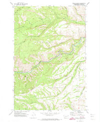
1971 Map of Weddle Canyon
USGS Topo · Published 1974About this map
Snoqualmie National Forest dominates this landscape in Yakima County, where the Tieton River carves a path through the canyon floor. The map highlights the engineered infrastructure of the early 1970s, specifically the Yakima Tieton Main Canal and its associated flumes that parallel the riverbed. This irrigation network is a defining element of the valley's development, contrasted by the steep, primitive terrain of Bear Canyon and Hoover Canyon to the north.
Find a feature on this map
30 named features on this map. Tap any name to fly to it.
Don’t see what you’re looking for? This feature index may not catch every label — zoom into the map to look around manually.
Map Details
Editions of this 1971 Weddle Canyon Map
2 editions found
Other maps of this area

1899 · Ellensburg
USGS Topo · 1:125,000

1901 · Ellensburg
USGS Topo · 1:125,000

1902 · Mount Aix
USGS Topo · 1:125,000

1904 · Mt Aix
USGS Topo · 1:125,000

1950 · Yakima
USGS Topo · 1:250,000

1958 · Yakima
USGS Topo · 1:250,000

1961 · Yakima
USGS Topo · 1:250,000

1967 · Tieton Basin
USGS Topo · 1:24,000
1967 · Foundation Ridge
USGS Topo · 1:24,000

1971 · Nile
USGS Topo · 1:24,000