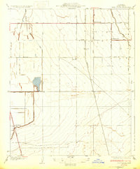
1933 Map of Weed Patch
USGS Topo · Published 1933About this map
Agricultural development in Kern County is clearly defined in this 1930 survey, which highlights the intersection of gravity-fed irrigation and early motor infrastructure. The settlement at Weed Patch serves as a northern hub, connected by the Weed Patch Highway to the surrounding fields. The landscape is carved by an extensive water management network, including the Central Branch Kern Island Canal, the Adobe Canal, and the Kern Island Drain, which converted this portion of the San Joaquin Valley into productive farmland. Toward the south, the New U S Highway 99 cuts across the corner near an Airway Beacon, signaling the era's advancing transportation technology. Local landmarks like the Vineland Sch and Teel Ranch provide specific touchpoints for genealogists tracing family footprints in the region's ranching and farming history.
Find a feature on this map
25 named features on this map. Tap any name to fly to it.
Don’t see what you’re looking for? This feature index may not catch every label — zoom into the map to look around manually.
Map Details
Editions of this 1933 Weed Patch Map
3 editions found
Other maps of this area

1910 · Buena Vista Lake
USGS Topo · 1:125,000

1912 · Buena Vista Lake
USGS Topo · 1:125,000

1914 · Caliente
USGS Topo · 1:125,000

1929 · Fairfax School
USGS Topo · 1:31,680

1930 · Weed Patch
USGS Topo · 1:31,680

1930 · Arvin
USGS Topo · 1:31,680

1930 · Conner
USGS Topo · 1:31,680

1931 · West of Tejon Hills
USGS Topo · 1:31,680

1931 · Edison
USGS Topo · 1:31,680

1931 · Tejon Hills
USGS Topo · 1:31,680