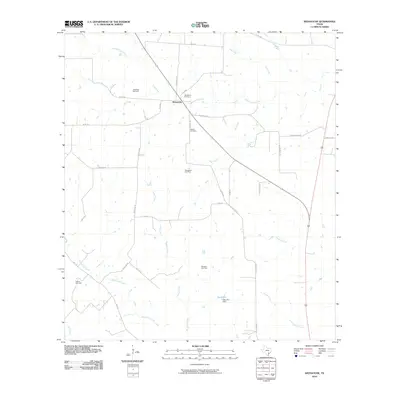
2010 Map of Weesatche
USGS Topo · Published 2010About this map
The unincorporated community of Weesatche sits at a crossroads in Goliad County, where local roads like E FM 884 and Church Rd intersect. This South Texas landscape is defined by its drainage systems and energy production, with numerous gas fields including the Gottschalt Gas Field and Poehler Gas Field dotting the ranch land. The terrain is carved by the winding paths of Eighteenmile Creek, Manahuilla Creek, and Cow Creek, which provide natural boundaries between the large land holdings. For genealogists and local historians, the presence of Woodlawn Cemetery and Barnes Cemetery provides critical physical links to the settlement's early families. To the south, Dye Lake and the Dye Lake Dam represent significant water management features in this predominantly agricultural and resource-rich territory.
Find a feature on this map
36 named features on this map. Tap any name to fly to it.
Don’t see what you’re looking for? This feature index may not catch every label — zoom into the map to look around manually.
Map Details
Editions of this 2010 Weesatche Map
This is the sole edition of this map. No revisions or reprints were ever made.
Other maps of this area

1953 · Beeville
USGS Topo · 1:250,000

1956 · Beeville
USGS Topo · 1:250,000

1960 · Beeville
USGS Topo · 1:250,000

1962 · Hensley Lake
USGS Topo · 1:24,000

1962 · Goliad
USGS Topo · 1:24,000

1963 · Meyersville
USGS Topo · 1:24,000

1963 · Weesatche
USGS Topo · 1:24,000
1963 · Yorktown West
USGS Topo · 1:24,000
1963 · Runge SE
USGS Topo · 1:24,000
1963 · Yorktown East
USGS Topo · 1:24,000