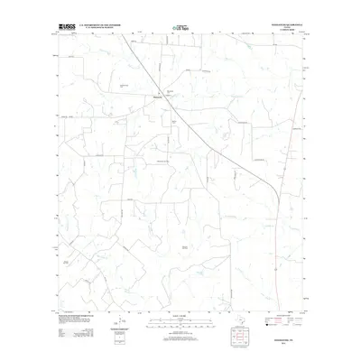
2013 Map of Weesatche
USGS Topo · Published 2013About this map
The community of Weesatche serves as the hub for this section of Goliad County, where local roads like E Main St and Church Rd intersect. The landscape is defined by its energy production and rural heritage, evidenced by the numerous extraction sites such as the Gottschalt Gas Field and Marshall Gas Field that dot the countryside. This era shows a topography shaped by a dense network of seasonal and perennial waterways, including Eighteenmile Cr and the winding Manahuilla Cr, which drain the open ranch land toward the Gulf Coast. Genealogists will find point-of-interest data at Woodlawn Cem and Barnes Cem, which sit near the main settlement and the banks of Hog Cr. The presence of Dye Lake and various smaller creeks like Perdido Cr illustrate the drainage patterns essential to the local agricultural economy.
Find a feature on this map
39 named features on this map. Tap any name to fly to it.
Don’t see what you’re looking for? This feature index may not catch every label — zoom into the map to look around manually.
Map Details
Editions of this 2013 Weesatche Map
This is the sole edition of this map. No revisions or reprints were ever made.
Other maps of this area

1953 · Beeville
USGS Topo · 1:250,000

1956 · Beeville
USGS Topo · 1:250,000

1960 · Beeville
USGS Topo · 1:250,000

1962 · Hensley Lake
USGS Topo · 1:24,000

1962 · Goliad
USGS Topo · 1:24,000

1963 · Meyersville
USGS Topo · 1:24,000

1963 · Weesatche
USGS Topo · 1:24,000
1963 · Yorktown West
USGS Topo · 1:24,000
1963 · Runge SE
USGS Topo · 1:24,000
1963 · Yorktown East
USGS Topo · 1:24,000