
1907 Map of Weingarten
USGS Topo · Published 1961About this map
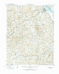
Ste. Genevieve County reveals a complex topography of deep creek bottoms and upland ridges in this 1907 survey, which was partially revised in 1949. The landscape is defined by the heavy drainage of River aux Vases and Saline Creek as they move toward the Mississippi River near Moro Island. Settlement patterns show distinct clusters like New Offenburg and Weingarten, connected by early thoroughfares such as the Illinois Southern Road and the Ste Genevieve and Perryville Road.
Find a feature on this map
61 named features on this map. Tap any name to fly to it.
Don’t see what you’re looking for? This feature index may not catch every label — zoom into the map to look around manually.
Map Details
Editions of this 1907 Weingarten Map
2 editions found
Other maps of this area

1904 · Farmington
USGS Topo · 1:62,500

1906 · Farmington
USGS Topo · 1:62,500

1909 · Weingarten
USGS Topo · 1:62,500

1910 · Higdon
USGS Topo · 1:62,500

1912 · Baldwin
USGS Topo · 1:62,500

1914 · Baldwin
USGS Topo · 1:62,500

1915 · Renault
USGS Topo · 1:62,500

1915 · Chester
USGS Topo · 1:62,500

1915 · Crystal City
USGS Topo · 1:62,500

1923 · Perryville
USGS Topo · 1:62,500