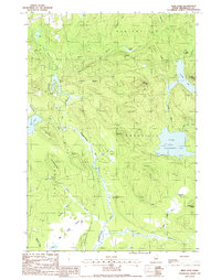
1988 Map of Weir Pond
USGS Topo · Published 1988About this map
The Passadumkeag River snakes through the center of this Maine landscape, forming a complex waterway of bogs and sharp bends including The Oxbow. Small outposts of activity are scattered across the terrain, notably at Budge Farm, Carry Farm, and isolated sites like Camp No 9 and Camp No 11. These locations, alongside the vast 1000 Acre Heath, reflect a region defined by logging and seasonal camps rather than dense town centers.
Find a feature on this map
44 named features on this map. Tap any name to fly to it.
Don’t see what you’re looking for? This feature index may not catch every label — zoom into the map to look around manually.
Map Details
Editions of this 1988 Weir Pond Map
This is the sole edition of this map. No revisions or reprints were ever made.
Other maps of this area

1920 · Winn
USGS Topo · 1:62,500

1931 · Springfield
USGS Topo · 1:48,000

1931 · Saponac
USGS Topo · 1:48,000

1932 · Nicatous Lake
USGS Topo · 1:48,000

1934 · Saponac
USGS Topo · 1:62,500

1934 · Nicatous Lake
USGS Topo · 1:62,500

1934 · Springfield
USGS Topo · 1:62,500

1954 · Millinocket
USGS Topo · 1:250,000

1957 · Saponac
USGS Topo · 1:62,500

1958 · Millinocket
USGS Topo · 1:250,000