
1980 Map of Weiser
USGS Topo · Published 1993About this map
The Snake River corridor anchors this regional study, defining the border between Idaho and Oregon as it flows past Weiser and Payette. This 1980 survey, photoinspected in 1990, illustrates the intricate water management and transport networks essential to the area, featuring the Union Pacific rail lines and reservoirs like Crane Creek Reservoir and Paddock Valley Reservoir. The landscape transitions from the agricultural river bottoms of Dead Ox Flat and Sand Hollow to the high elevations of the West Mountains and Boise Mountains.
Find a feature on this map
83 named features on this map. Tap any name to fly to it.
Don’t see what you’re looking for? This feature index may not catch every label — zoom into the map to look around manually.
Map Details
Editions of this 1980 Weiser Map
This is the sole edition of this map. No revisions or reprints were ever made.
Other maps of this area

1892 · Boise
USGS Topo · 1:125,000

1894 · Squaw Creek
USGS Topo · 1:125,000

1894 · Idaho Basin
USGS Topo · 1:125,000

1897 · Boise
USGS Topo · 1:125,000

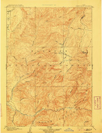
1897 · Weiser
USGS Topo · 1:125,000

1898 · Nampa
USGS Topo · 1:125,000

1906 · Mitchell Butte
USGS Topo · 1:125,000
1909 · Garden Valley
USGS Topo · 1:125,000

1911 · Meadows
USGS Topo · 1:125,000

1915 · Pine
USGS Topo · 1:125,000