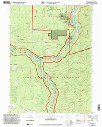
1997 Map of Weitchpec
USGS Topo · Published 2001About this map
The confluence of the Klamath River and Trinity River serves as the focal point for this northern California landscape, centered on the settlement of Weitchpec. This 1997 revision highlights the overlapping jurisdictions and cultural history of the region, where the Hoopa Valley Indian Reservation meets the Six Rivers National Forest. Local history is preserved in site-specific markers such as the Essenpries Mill Cem (Site) and various named camps like Butte Camp and Bloody Camp, which suggest the area's legacy of early industry and back-country travel.
Find a feature on this map
61 named features on this map. Tap any name to fly to it.
Don’t see what you’re looking for? This feature index may not catch every label — zoom into the map to look around manually.
Map Details
Editions of this 1997 Weitchpec Map
This is the sole edition of this map. No revisions or reprints were ever made.
Other maps of this area

1925 · Hoopa
USGS Topo · 1:125,000

1945 · Coyote Peak
USGS Topo · 1:62,500

1945 · Tectah Creek
USGS Topo · 1:62,500

1948 · Weed
USGS Topo · 1:250,000

1950 · Weed
USGS Topo · 1:250,000

1952 · Coyote Peak
USGS Topo · 1:62,500

1952 · Hoopa
USGS Topo · 1:62,500

1952 · Orleans
USGS Topo · 1:62,500

1952 · Tectah Creek
USGS Topo · 1:62,500

1958 · Weed
USGS Topo · 1:250,000