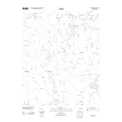
2013 Map of Welcome
USGS Topo · Published 2013About this map
Welcome anchors this portion of Davidson and Forsyth counties, serving as a hub for the surrounding rural communities of Arcadia, Enterprise, and Arnold. The landscape is defined by the drainage systems of the Yadkin River and its numerous tributaries, including Reedy Cr, Huffmans Cr, and Miller Cr. These waterways historically dictated the location of early industrial sites like Eureka Mills and Old Mill, which appear alongside long-standing local landmarks such as Friedburg Church and Centenary Church. The area retains a mix of established agricultural land and newer residential clusters like Nestleway Acres. For genealogists and local historians, the map's detailed road network—including family-named routes like Phelps Farm Rd and Allen Yountz Ln—provides a clear view of the community's development pattern and the proximity of institutional centers like Reedy Creek School.
Find a feature on this map
266 named features on this map. Tap any name to fly to it.
Don’t see what you’re looking for? This feature index may not catch every label — zoom into the map to look around manually.
Map Details
Editions of this 2013 Welcome Map
This is the sole edition of this map. No revisions or reprints were ever made.
Other maps of this area

1949 · Eller
USGS Topo · 1:24,000

1950 · Winston-Salem West
USGS Topo · 1:24,000

1950 · Lexington East
USGS Topo · 1:24,000

1950 · Winston-Salem East
USGS Topo · 1:24,000

1950 · Lexington West
USGS Topo · 1:24,000

1950 · Churchland
USGS Topo · 1:24,000

1951 · Winston-Salem West
USGS Topo · 1:24,000

1951 · Winston-Salem East
USGS Topo · 1:24,000

1951 · Churchland
USGS Topo · 1:24,000

1951 · Lexington East
USGS Topo · 1:24,000