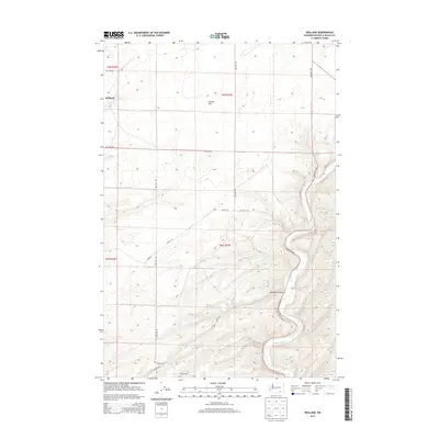
2013 Map of Welland
USGS Topo · Published 2013About this map
Welland sits at the edge of the expansive Eureka Flat in Walla Walla County, where the plateau begins its descent toward the river valley. The landscape is defined by the winding course of the Touchet River as it carves through the southeast corner of the map, creating the deep recesses of Ninemile Canyon. This agricultural region is meticulously partitioned by a grid of rural routes, including Britton Rd and Kellogg Rd, which serve the expansive fields of the northern flats. The terrain shift is striking, moving from the level agricultural tracts of the north into the sharp, contoured draws that lead down to the riverbanks. This transition illustrates the historical reliance on the river's path for drainage and early transit while the upper flats were developed for large-scale farming.
Find a feature on this map
17 named features on this map. Tap any name to fly to it.
Don’t see what you’re looking for? This feature index may not catch every label — zoom into the map to look around manually.
Map Details
Editions of this 2013 Welland Map
This is the sole edition of this map. No revisions or reprints were ever made.
Other maps of this area

1915 · Wallulah
USGS Topo · 1:96,000

1918 · Wallula
USGS Topo · 1:125,000

1953 · Walla Walla
USGS Topo · 1:250,000

1958 · Walla Walla
USGS Topo · 1:250,000

1964 · Zangar Junction
USGS Topo · 1:24,000

1964 · Levey SE
USGS Topo · 1:24,000

1964 · Slater
USGS Topo · 1:24,000

1966 · Page
USGS Topo · 1:24,000
1966 · Touchet
USGS Topo · 1:24,000

1966 · Rulo
USGS Topo · 1:24,000