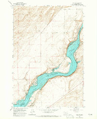
1964 Map of Levey SE
USGS Topo · Published 1965About this map
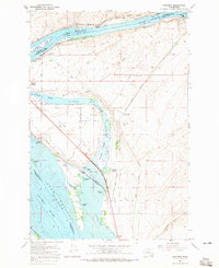
Lake Sacajawea dominates the center of this mid-1960s survey, representing a significant transformation of the Snake River landscape along the border of Franklin and Walla Walla counties. The map captures the shoreline at a normal pool elevation of 440 feet, submerging much of the previous riverbed while creating new recreation and infrastructure points like Fishhook Park and Levey Landing. The industrial character of the era is evidenced by the heavy presence of major rail lines, including the Spokane Portland and Seattle and the Union Pacific, which parallel the water's edge.
Find a feature on this map
27 named features on this map. Tap any name to fly to it.
Don’t see what you’re looking for? This feature index may not catch every label — zoom into the map to look around manually.
Map Details
Editions of this 1964 Levey SE Map
This is the sole edition of this map. No revisions or reprints were ever made.
Other maps of this area

1915 · Wallulah
USGS Topo · 1:96,000

1918 · Wallula
USGS Topo · 1:125,000

1953 · Walla Walla
USGS Topo · 1:250,000

1958 · Walla Walla
USGS Topo · 1:250,000
1963 · Rye Grass Coulee
USGS Topo · 1:24,000
1964 · Levey SW
USGS Topo · 1:24,000
1964 · Slater
USGS Topo · 1:24,000
1964 · Levey NE
USGS Topo · 1:24,000
1964 · Humorist
USGS Topo · 1:24,000

1966 · Page
USGS Topo · 1:24,000