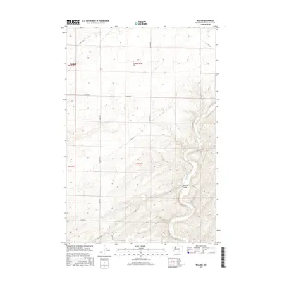
2017 Map of Welland
USGS Topo · Published 2017About this map
Eureka Flat dominates the northern landscape of this Walla Walla County region, showcasing the open, agricultural character of the Palouse-adjacent hills. The Touchet River winds through the eastern portion of the map, carving its way through the terrain toward Ninemile Canyon in the south. This 2017 survey by the U.S. Geological Survey captures the rural infrastructure of the settlement at Welland, where a network of section-line roads like Britton Rd and Gluck Rd delineate the vast wheat-growing plateaus. The topography is defined by the contrast between the level stretches of the flats and the intricate drainage patterns feeding into the river valley, reflecting a landscape shaped by both geological history and modern large-scale farming practices. Family-named corridors such as Luckenbill Rd and Dodd Rd provide a clear view of how land ownership and transport have remained rooted in the rural geography of southeastern Washington.
Find a feature on this map
20 named features on this map. Tap any name to fly to it.
Don’t see what you’re looking for? This feature index may not catch every label — zoom into the map to look around manually.
Map Details
Editions of this 2017 Welland Map
This is the sole edition of this map. No revisions or reprints were ever made.
Other maps of this area

1915 · Wallulah
USGS Topo · 1:96,000

1918 · Wallula
USGS Topo · 1:125,000

1953 · Walla Walla
USGS Topo · 1:250,000

1958 · Walla Walla
USGS Topo · 1:250,000

1964 · Zangar Junction
USGS Topo · 1:24,000

1964 · Levey SE
USGS Topo · 1:24,000

1964 · Slater
USGS Topo · 1:24,000

1966 · Page
USGS Topo · 1:24,000
1966 · Touchet
USGS Topo · 1:24,000

1966 · Rulo
USGS Topo · 1:24,000