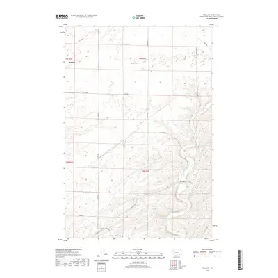
2020 Map of Welland
USGS Topo · Published 2020About this map
The Touchet River winds through the southeastern corner of this landscape, carving a valley below the agricultural uplands of Walla Walla County. The small settlement of Welland sits at the intersection of local routes, including Welland Rd, serving as a focal point in a region defined by extensive dryland farming. Wide depressions like Eureka Flat and Ash Hollow illustrate the distinct topography of this part of the Columbia Basin. The map details an intricate network of rural corridors such as Britton Rd, Luckenbill Rd, and Plucker Rd, which follow the section lines and natural coulees that define the local property boundaries and access points for the area's agricultural operations.
Find a feature on this map
20 named features on this map. Tap any name to fly to it.
Don’t see what you’re looking for? This feature index may not catch every label — zoom into the map to look around manually.
Map Details
Editions of this 2020 Welland Map
This is the sole edition of this map. No revisions or reprints were ever made.
Other maps of this area

1915 · Wallulah
USGS Topo · 1:96,000

1918 · Wallula
USGS Topo · 1:125,000

1953 · Walla Walla
USGS Topo · 1:250,000

1958 · Walla Walla
USGS Topo · 1:250,000

1964 · Zangar Junction
USGS Topo · 1:24,000

1964 · Levey SE
USGS Topo · 1:24,000

1964 · Slater
USGS Topo · 1:24,000

1966 · Page
USGS Topo · 1:24,000
1966 · Touchet
USGS Topo · 1:24,000

1966 · Rulo
USGS Topo · 1:24,000