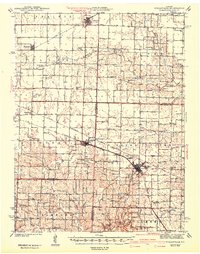
1942 Map of Wellsville
USGS Topo · Published 1942About this map
Wellsville and Martinsburg serve as the primary rail-oriented hubs of this central Missouri landscape, which spans the borders of Audrain, Montgomery, and Callaway counties. Surveyed just before the Second World War, the map illustrates an economy driven by agriculture and industry, with the Eclede Christy Mine and several major rail lines including the Wabash and Chicago Burlington And Quincy providing the infrastructure for growth. The northern portion of the quadrangle is dominated by the Prairie, a flatter terrain that gives way to more dissected drainage basins in the south.
Find a feature on this map
71 named features on this map. Tap any name to fly to it.
Don’t see what you’re looking for? This feature index may not catch every label — zoom into the map to look around manually.
Map Details
Editions of this 1942 Wellsville Map
2 editions found
Other maps of this area

1890 · Louisiana
USGS Topo · 1:125,000

1890 · Mexico
USGS Topo · 1:125,000

1890 · Hermann
USGS Topo · 1:125,000

1890 · Fulton
USGS Topo · 1:125,000

1928 · Fulton
USGS Topo · 1:62,500

1931 · Fulton
USGS Topo · 1:62,500

1932 · Mexico
USGS Topo · 1:62,500

1940 · Montgomery City
USGS Topo · 1:62,500

1942 · Montgomery City
USGS Topo · 1:62,500

1942 · Wellsville
USGS Topo · 1:62,500