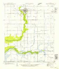
1954 Map of Welsh
USGS Topo · Published 1954About this map
The town of Welsh sits at the northern edge of this coastal prairie landscape, defined by its position along the Southern Pacific railroad and U S Highway No 90. This mid-century survey illustrates a region dominated by water management and agriculture, where natural waterways like East Bayou Lacassine and Bayou Chene are integrated into a complex network of man-made infrastructure. The map documents several irrigation and drainage systems vital to the local rice-growing economy, including the Welsh Canal, Sturdivant Canal, and Farm Canal.
Find a feature on this map
18 named features on this map. Tap any name to fly to it.
Don’t see what you’re looking for? This feature index may not catch every label — zoom into the map to look around manually.
Map Details
Editions of this 1954 Welsh Map
This is the sole edition of this map. No revisions or reprints were ever made.
Other maps of this area

1946 · Lacassine
USGS Topo · 1:31,680

1946 · Lake Arthur
USGS Topo · 1:31,680

1946 · Hayes
USGS Topo · 1:31,680

1946 · Jennings
USGS Topo · 1:31,680

1947 · Fenton
USGS Topo · 1:31,680

1947 · Thornwell
USGS Topo · 1:31,680

1947 · Pine Island
USGS Topo · 1:31,680

1947 · Welsh
USGS Topo · 1:31,680

1947 · Hathaway
USGS Topo · 1:31,680
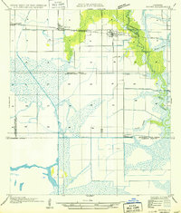
1949 · Hayes
USGS Topo · 1:31,680