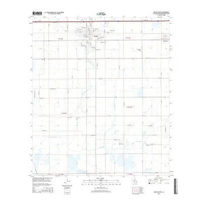
2015 Map of Welsh South
USGS Topo · Published 2015About this map
Welsh serves as the primary hub of this Jefferson Davis Parish landscape, exhibiting a dense residential grid defined by streets such as Millard St and S Elm St. The area's agricultural and aviation heritage is clear, with both the Welsh Airport and the specialized Ag Aviation Airport supporting the surrounding fields. The low-lying terrain is meticulously managed by a network of waterways, including the winding course of East Bayou Lacassine and the engineered paths of the Welsh Canal and Niblett Canal. To the east, the settlement of Roanoke sits along the rail corridor, while the Foreman Cem provides a point of genealogical interest south of the main town. The map reveals a transition from the structured blocks of the town center to the vast, water-fed agricultural tracts drained by Bayou Chene, illustrating the region's long-standing reliance on irrigation and drainage for its prairie-based economy.
Find a feature on this map
84 named features on this map. Tap any name to fly to it.
Don’t see what you’re looking for? This feature index may not catch every label — zoom into the map to look around manually.
Map Details
Editions of this 2015 Welsh South Map
This is the sole edition of this map. No revisions or reprints were ever made.
Other maps of this area

1946 · Lacassine
USGS Topo · 1:31,680

1946 · Lake Arthur
USGS Topo · 1:31,680

1946 · Hayes
USGS Topo · 1:31,680

1946 · Jennings
USGS Topo · 1:31,680

1947 · Fenton
USGS Topo · 1:31,680

1947 · Thornwell
USGS Topo · 1:31,680

1947 · Pine Island
USGS Topo · 1:31,680

1947 · Welsh
USGS Topo · 1:31,680

1947 · Hathaway
USGS Topo · 1:31,680
1949 · Hayes
USGS Topo · 1:31,680