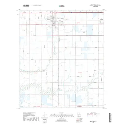
2018 Map of Welsh South
USGS Topo · Published 2018About this map
Agricultural aviation and traditional rice country define this section of Jefferson Davis Parish, where the settlement of Welsh serves as a central hub. The landscape is heavily influenced by water management, notably the Welsh Canal and its associated roadways, which support the region's long-standing farming operations. The town grid includes historically significant corridors such as NW Railroad Ave and W Russell Ave, while the surrounding prairie is dotted with industrial markers like the Welsh Airport and the Ag Aviation Airport, reflecting the importance of crop dusting to the local economy.
Find a feature on this map
85 named features on this map. Tap any name to fly to it.
Don’t see what you’re looking for? This feature index may not catch every label — zoom into the map to look around manually.
Map Details
Editions of this 2018 Welsh South Map
This is the sole edition of this map. No revisions or reprints were ever made.
Other maps of this area

1946 · Lacassine
USGS Topo · 1:31,680

1946 · Lake Arthur
USGS Topo · 1:31,680

1946 · Hayes
USGS Topo · 1:31,680

1946 · Jennings
USGS Topo · 1:31,680

1947 · Fenton
USGS Topo · 1:31,680

1947 · Thornwell
USGS Topo · 1:31,680

1947 · Pine Island
USGS Topo · 1:31,680

1947 · Welsh
USGS Topo · 1:31,680

1947 · Hathaway
USGS Topo · 1:31,680
1949 · Hayes
USGS Topo · 1:31,680