
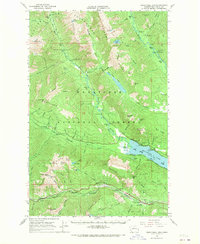
1965 Map of Wenatchee Lake
USGS Topo · Published 1967About this map
The Great Northern railroad corridor dictates the southern topography of this 1960s survey, threading through the high country past the remote settlements of Berne and Merritt. To the north, the landscape is defined by the convergence of the Little Wenatchee River and the White River as they feed into the expansive Lake Wenatchee. This era shows a well-developed recreational and seasonal infrastructure, including established sites like Camp Zanika Lache, Telma, and the Lake Wenatchee Campground. Elevated surveillance for forestry management is prominent, marked by the presence of the Dirtyface Lookout and Alpine Lookout. The wilderness character remains preserved in the upper reaches of the Glacier Peak Wilderness, where rugged peaks such as Mt David and Mt Howard overlook numerous alpine lakes and pack trails, including the Indian Creek Pack Trail.
Find a feature on this map
84 named features on this map. Tap any name to fly to it.
Don’t see what you’re looking for? This feature index may not catch every label — zoom into the map to look around manually.
Map Details
Editions of this 1965 Wenatchee Lake Map
2 editions found
Other maps of this area

1899 · Glacier Peak
USGS Topo · 1:125,000

1901 · Glacier Peak
USGS Topo · 1:125,000

1901 · Chiwaukum
USGS Topo · 1:125,000

1902 · Skykomish
USGS Topo · 1:125,000

1902 · Stehekin
USGS Topo · 1:125,000

1904 · Stehekin
USGS Topo · 1:125,000

1904 · Chiwaukum
USGS Topo · 1:125,000

1905 · Skykomish
USGS Topo · 1:125,000

1944 · Holden
USGS Topo · 1:62,500

1944 · Lucerne
USGS Topo · 1:62,500