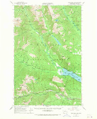
1965 Map of Wenatchee Lake
USGS Topo · Published 1970About this map
Wenatchee Lake dominates the central landscape of this 1965 survey, serving as a hub for mountain recreation and early settlement. Along its shores and the surrounding river valleys, the map captures a transition from wilderness to established campsites and camps like Camp Zanika Lache and Tall Timber Ranch. To the south, the Great Northern railroad tracks follow the course of Nason Creek, connecting the small mountain stops of Merritt and Berne.
Find a feature on this map
87 named features on this map. Tap any name to fly to it.
Don’t see what you’re looking for? This feature index may not catch every label — zoom into the map to look around manually.
Map Details
Editions of this 1965 Wenatchee Lake Map
2 editions found

Other maps of this area

1899 · Glacier Peak
USGS Topo · 1:125,000

1901 · Glacier Peak
USGS Topo · 1:125,000

1901 · Chiwaukum
USGS Topo · 1:125,000

1902 · Skykomish
USGS Topo · 1:125,000

1902 · Stehekin
USGS Topo · 1:125,000

1904 · Stehekin
USGS Topo · 1:125,000

1904 · Chiwaukum
USGS Topo · 1:125,000

1905 · Skykomish
USGS Topo · 1:125,000

1944 · Holden
USGS Topo · 1:62,500

1944 · Lucerne
USGS Topo · 1:62,500