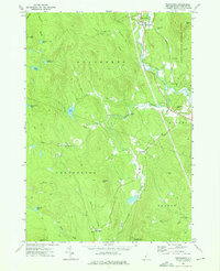
1974 Map of Wentworth
USGS Topo · Published 1975About this map
The Baker River and its South Branch Baker River define the eastern valley of this New Hampshire quadrangle, where the town of Wentworth serves as a primary hub. In the mid-1970s, the landscape was largely shaped by the transition from industrial utility to conservation, visible in the Old Railroad Grade and the vast reach of the White Mountain National Forest. Small mountain settlements like Cheever, North Dorchester, and Dorchester are connected by winding routes like the Eastside Road, reflecting a local economy tied to the land and the river.
Find a feature on this map
43 named features on this map. Tap any name to fly to it.
Don’t see what you’re looking for? This feature index may not catch every label — zoom into the map to look around manually.
Map Details
Editions of this 1974 Wentworth Map
Other maps of this area

1927 · Cardigan
USGS Topo · 1:62,500

1927 · Mascoma
USGS Topo · 1:62,500

1928 · Rumney
USGS Topo · 1:62,500

1930 · Cardigan
USGS Topo · 1:62,500

1931 · Mt. Cube
USGS Topo · 1:62,500

1932 · Mascoma
USGS Topo · 1:62,500

1932 · Rumney
USGS Topo · 1:62,500

1933 · Mt. Cube
USGS Topo · 1:62,500

1949 · Portland
USGS Topo · 1:250,000

1950 · Glens Falls
USGS Topo · 1:250,000