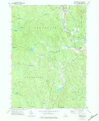
1974 Map of Wentworth
USGS Topo · Published 1984About this map
The Baker River and its South Branch define the settlement patterns of this New Hampshire landscape, where the village of Wentworth serves as a local focal point near the northern edge of the sheet. To the south and west, the terrain rises into the timbered reaches of the White Mountain National Forest and Province Road State Forest. This 1974 survey captures the area’s transition from early industrial reliance on the river and rail to a more recreational and conservation-focused character.
Find a feature on this map
40 named features on this map. Tap any name to fly to it.
Don’t see what you’re looking for? This feature index may not catch every label — zoom into the map to look around manually.
Map Details
Editions of this 1974 Wentworth Map
Other maps of this area

1927 · Cardigan
USGS Topo · 1:62,500

1927 · Mascoma
USGS Topo · 1:62,500

1928 · Rumney
USGS Topo · 1:62,500

1930 · Cardigan
USGS Topo · 1:62,500

1931 · Mt. Cube
USGS Topo · 1:62,500

1932 · Mascoma
USGS Topo · 1:62,500

1932 · Rumney
USGS Topo · 1:62,500

1933 · Mt. Cube
USGS Topo · 1:62,500

1949 · Portland
USGS Topo · 1:250,000

1950 · Glens Falls
USGS Topo · 1:250,000