1979 Map of Wentzville
USGS Topo · Published 1980About this map
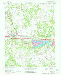
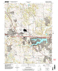
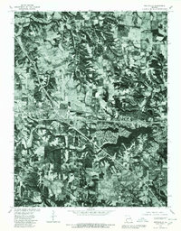
Wentzville stands as the central hub in this late-1970s orthophotoquad, showing the town at a point of significant transition where the growing community meets the agricultural landscape of St. Charles County. To the east, the sprawling residential shoreline of Lake St Louis is clearly visible, its development contrasting sharply with the long, thin agricultural plots and forested creek bottoms that dominate the surrounding area. The imagery captures the winding courses of Peruque Creek and Dardenne Creek as they cut through the terrain toward the Missouri River. Smaller settlements like Flint Hill, Josephville, and Gilmore are shown as rural crossroads, providing a clear look at the historic settlement patterns before the rapid suburban expansion of the late twentieth century.
Find a feature on this map
7 named features on this map. Tap any name to fly to it.
Don’t see what you’re looking for? This feature index may not catch every label — zoom into the map to look around manually.
Map Details
Editions of this 1979 Wentzville Map
This is the sole edition of this map. No revisions or reprints were ever made.
Historical Maps of O'Fallon Through Time
7 maps found