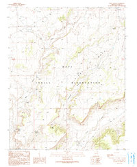
1990 Map of Wepo Village
USGS Topo · Published 1991About this map
The Hopi Indian Reservation landscape is defined by the towering prominence of First Mesa and the intricate drainage network of Wepo Wash. This 1990 survey captures a region where water management and traditional settlement patterns are central to the terrain. Near the cluster of Wepo Village, numerous water sources including Wepo Spring, Sand Hill Spring, and Donkey Spring appear alongside several corrals, reflecting the pastoral and residential life of the era. The presence of a local Cemetery and a Historical Monument near the southern boundary provides important touchstones for genealogical and local history research. Throughout the region, man-made Check Dams and a Flowing Well indicate a sustained effort to manage the arid environment, while the shifting Sand Hills and deep cuts of One Cottonwood Canyon define the physical geography.
Find a feature on this map
22 named features on this map. Tap any name to fly to it.
Don’t see what you’re looking for? This feature index may not catch every label — zoom into the map to look around manually.
Map Details
Editions of this 1990 Wepo Village Map
This is the sole edition of this map. No revisions or reprints were ever made.
Other maps of this area

1883 · Marsh Pass
USGS Topo · 1:250,000

1883 · Tusayan
USGS Topo · 1:250,000

1886 · Tusayan
USGS Topo · 1:250,000

1892 · Marsh Pass
USGS Topo · 1:250,000

1947 · Flagstaff
USGS Topo · 1:250,000

1954 · Flagstaff
USGS Topo · 1:250,000

1956 · Marble Canyon
USGS Topo · 1:250,000

1958 · Flagstaff
USGS Topo · 1:250,000

1959 · Marble Canyon
USGS Topo · 1:250,000

1960 · Flagstaff
USGS Topo · 1:250,000