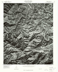
1976 Map of Wesser
USGS Topo · Published 1976About this map
Fontana Lake and the winding course of the Little Tennessee River dominate this orthophotoquad, which captures the intersection of river valleys and high ridges in the mid-1970s. The landscape is defined by the sharp elevations of the Nantahala Mountains and Breedlove Mountain, where settlement patterns closely follow the narrow corridors of the Nantahala River and existing road networks. Local hamlets such as Wesser, Almond, and Lauada are visible as small clearings within the dense forest cover. This photographic record, produced from March 1976 aerial imagery, offers an unmediated view of land use and vegetation during a period when these mountain communities were connected by Route 19 and Route 28. It reveals the physical relationship between isolated settlements like Briertown and Tellico and the formidable topography of the region.
Find a feature on this map
13 named features on this map. Tap any name to fly to it.
Don’t see what you’re looking for? This feature index may not catch every label — zoom into the map to look around manually.
Map Details
Editions of this 1976 Wesser Map
This is the sole edition of this map. No revisions or reprints were ever made.
Other maps of this area

1891 · Cowee
USGS Topo · 1:125,000

1897 · Cowee
USGS Topo · 1:125,000

1907 · Cowee
USGS Topo · 1:125,000

1933 · Bryson
USGS Topo · 1:62,500

1933 · Bushnell
USGS Topo · 1:62,500

1935 · Franklin
USGS Topo · 1:24,000

1935 · Burningtown Bald
USGS Topo · 1:24,000

1935 · Topton
USGS Topo · 1:24,000

1935 · Wayah Bald
USGS Topo · 1:48,000

1936 · Proctor
USGS Topo · 1:24,000