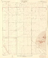
1933 Map of West Alpine Butte
USGS Topo · Published 1933About this map
Antelope Valley spreads across the northern Los Angeles County landscape in this 1930s survey, defined by a rigid grid of early desert roads. The prominent elevation of Alpine Butte anchors the eastern side of the sheet, rising sharply above the alluvial plains. This environment is characterized by ephemeral watercourses like Little Rock Wash and Rock Creek, which illustrate the drainage patterns toward the valley floor. Settlers and ranchers in areas like Tierra Bonita and Casa Desierta relied on scattered groundwater sources, indicated here by simple Well labels. The map reveals an early 20th-century stage of development where long thoroughfares such as Avenue J and Tierra Bonita Road were already being established to segment the high desert for future growth.
Find a feature on this map
16 named features on this map. Tap any name to fly to it.
Don’t see what you’re looking for? This feature index may not catch every label — zoom into the map to look around manually.
Map Details
Editions of this 1933 West Alpine Butte Map
3 editions found
Other maps of this area

1915 · Elizabeth Lake
USGS Topo · 1:125,000

1917 · Elizabeth Lake
USGS Topo · 1:125,000

1930 · Joshua
USGS Topo · 1:24,000

1930 · Lovejoy Springs
USGS Topo · 1:24,000

1930 · Roosevelt School
USGS Topo · 1:24,000

1930 · Little Rock
USGS Topo · 1:24,000

1930 · Llano
USGS Topo · 1:24,000

1930 · Casa Desierta
USGS Topo · 1:24,000

1930 · Pearland
USGS Topo · 1:24,000

1930 · West Alpine Butte
USGS Topo · 1:24,000