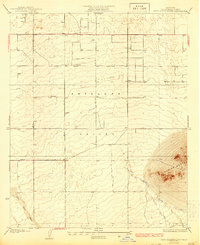
1933 Map of West Alpine Butte
USGS Topo · Published 1933About this map
Antelope Valley defines the character of this 1930s landscape, where the high desert floor is meticulously gridded by long stretches of dirt and gravel thoroughfares like Tierra Bonita Road and Avenue M. The prominent landform of Alpine Butte rises sharply in the southeast corner, providing a stark topographical contrast to the surrounding flats. This survey by J.L. Lewis captures a critical moment in Los Angeles County's desert development, when water access was the primary driver of settlement. Several isolated wells are noted across the quadrangle, highlighting the reliance on groundwater before modern infrastructure reached this reach of the Mojave. The ephemeral nature of the local hydrology is evident in the paths of Little Rock Wash and Little Rock Creek, which carve shifting channels through the southwest as they descend toward the valley floor.
Find a feature on this map
9 named features on this map. Tap any name to fly to it.
Don’t see what you’re looking for? This feature index may not catch every label — zoom into the map to look around manually.
Map Details
Editions of this 1933 West Alpine Butte Map
3 editions found
Other maps of this area

1915 · Elizabeth Lake
USGS Topo · 1:125,000

1917 · Elizabeth Lake
USGS Topo · 1:125,000

1930 · Joshua
USGS Topo · 1:24,000

1930 · Lovejoy Springs
USGS Topo · 1:24,000

1930 · Roosevelt School
USGS Topo · 1:24,000

1930 · Little Rock
USGS Topo · 1:24,000

1930 · Llano
USGS Topo · 1:24,000

1930 · Casa Desierta
USGS Topo · 1:24,000

1930 · Pearland
USGS Topo · 1:24,000

1930 · West Alpine Butte
USGS Topo · 1:24,000