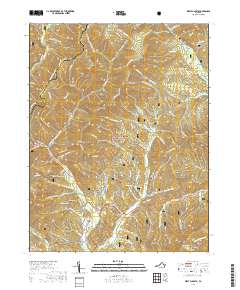
2019 Map of West Augusta
USGS Topo · Published 2019About this map
West Augusta serves as the primary settlement hub within this high-elevation landscape along the border of Augusta and Highland Counties. Much of the terrain is defined by the George Washington National Forest, where the complex drainage systems of Ramseys Draft and the Calfpasture River have carved deep ridges and drafts. For genealogists, the West Augusta Cem is a notable landmark near the junction of Deerfield Valley Rd and State Rte 715. The map illustrates a landscape transitioned largely to conservation and recreation, evidenced by the extensive network of the Wild Oak Trail and numerous named hollows like Georgia Camp Hollow and Freezland Hollow. Prominent peaks such as Hardscrabble Knob and The Pinnacle anchor the ridgelines, while small bodies of water like Braley Pond and Stark Pond punctuate the heavily forested draws.
Find a feature on this map
93 named features on this map. Tap any name to fly to it.
Don’t see what you’re looking for? This feature index may not catch every label — zoom into the map to look around manually.
Map Details
Editions of this 2019 West Augusta Map
This is the sole edition of this map. No revisions or reprints were ever made.
Other maps of this area

1894 · Staunton
USGS Topo · 1:125,000

1924 · Mc Dowell
USGS Topo · 1:62,500

1943 · Craigsville
USGS Topo · 1:62,500

1944 · Parnassus
USGS Topo · 1:62,500

1944 · Mc Dowell
USGS Topo · 1:62,500

1944 · Staunton
USGS Topo · 1:62,500

1945 · Craigsville
USGS Topo · 1:62,500

1946 · Mc Dowell
USGS Topo · 1:62,500

1947 · Staunton
USGS Topo · 1:62,500

1947 · Parnassus
USGS Topo · 1:62,500