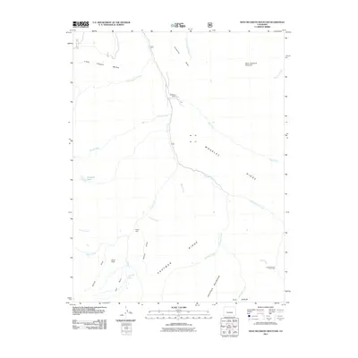
2011 Map of West Beckwith Mountain
USGS Topo · Published 2011About this map
Davenport Ranch and Navajo Cabin sit within a landscape defined by dramatic high-altitude relief and complex drainage systems in Gunnison County. This 2011 survey illustrates the land-use patterns of the central Colorado mountains, where seasonal outposts like Little Robinson Cow Camp dot the tributary valleys. The topography is anchored by the massive West Beckwith Mountain and Haystack Mountain, separated by the deep incisions of Robinson Creek and Kaufman Creek. Broad elevated plateaus, including Coal Creek Mesa and Snowshoe Mesa, provide a stark contrast to the narrow gulches and basins below. A network of Forest Service roads, such as 709 and 711, trace the path of Coal Creek, which serves as the primary longitudinal axis through this backcountry terrain.
Find a feature on this map
32 named features on this map. Tap any name to fly to it.
Don’t see what you’re looking for? This feature index may not catch every label — zoom into the map to look around manually.
Map Details
Editions of this 2011 West Beckwith Mountain Map
This is the sole edition of this map. No revisions or reprints were ever made.
Other maps of this area

1888 · Anthracite
USGS Topo · 1:62,500

1889 · Anthracite
USGS Topo · 1:62,500

1893 · Anthracite
USGS Topo · 1:62,500

1894 · Anthracite
USGS Topo · 1:62,500

1938 · Mt. Gunnison
USGS Topo · 1:48,000

1945 · Mount Gunnison
USGS Topo · 1:62,500

1956 · Montrose
USGS Topo · 1:250,000

1959 · Montrose
USGS Topo · 1:250,000

1960 · Montrose
USGS Topo · 1:250,000
1961 · Marcellina Mountain
USGS Topo · 1:24,000