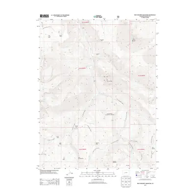
2013 Map of West Beckwith Mountain
USGS Topo · Published 2013About this map
West Beckwith Mountain and the high ridges of the Gunnison National Forest dominate this landscape, where the headwaters of numerous creeks carve through the West Elk Mountains. The map reveals a specialized alpine economy of high-altitude ranching and backcountry navigation, indicated by isolated outposts like the Little Robinson Cow Camp, Navajo Cabin, and Davenport Ranch. These sites are linked by a complex network of established trails, including the Through Line Trl and Kaufman Creek Trl, which follow the natural contours of the land above Coal Basin. Water remains a central feature of the terrain, with Gunnison Lake and drainage systems like Little Gunnison Cr and Robinson Cr defining the sharp verticality between landmarks such as Haystack Mountain and Coal Creek Mesa.
Find a feature on this map
46 named features on this map. Tap any name to fly to it.
Don’t see what you’re looking for? This feature index may not catch every label — zoom into the map to look around manually.
Map Details
Editions of this 2013 West Beckwith Mountain Map
This is the sole edition of this map. No revisions or reprints were ever made.
Other maps of this area

1888 · Anthracite
USGS Topo · 1:62,500

1889 · Anthracite
USGS Topo · 1:62,500

1893 · Anthracite
USGS Topo · 1:62,500

1894 · Anthracite
USGS Topo · 1:62,500

1938 · Mt. Gunnison
USGS Topo · 1:48,000

1945 · Mount Gunnison
USGS Topo · 1:62,500

1956 · Montrose
USGS Topo · 1:250,000

1959 · Montrose
USGS Topo · 1:250,000

1960 · Montrose
USGS Topo · 1:250,000
1961 · Marcellina Mountain
USGS Topo · 1:24,000