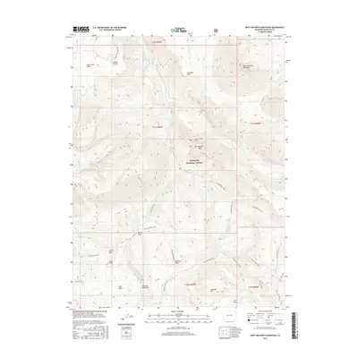
2016 Map of West Beckwith Mountain
USGS Topo · Published 2016About this map
West Beckwith Mountain and the surrounding high-altitude terrain of the Gunnison National Forest define this 2016 survey of Colorado’s wilderness. The map captures a complex network of ridgelines and watercourses, from the southern reaches of the West Elk Mountains to the broad expanse of Snowshoe Mesa. Unlike many developed regions, this area is characterized by its lack of permanent settlements, focused instead on the natural features like Coal Basin and the intriguing Beaver Jungle.
Find a feature on this map
48 named features on this map. Tap any name to fly to it.
Don’t see what you’re looking for? This feature index may not catch every label — zoom into the map to look around manually.
Map Details
Editions of this 2016 West Beckwith Mountain Map
This is the sole edition of this map. No revisions or reprints were ever made.
Other maps of this area

1888 · Anthracite
USGS Topo · 1:62,500

1889 · Anthracite
USGS Topo · 1:62,500

1893 · Anthracite
USGS Topo · 1:62,500

1894 · Anthracite
USGS Topo · 1:62,500

1938 · Mt. Gunnison
USGS Topo · 1:48,000

1945 · Mount Gunnison
USGS Topo · 1:62,500

1956 · Montrose
USGS Topo · 1:250,000

1959 · Montrose
USGS Topo · 1:250,000

1960 · Montrose
USGS Topo · 1:250,000
1961 · Marcellina Mountain
USGS Topo · 1:24,000