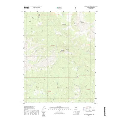
2019 Map of West Beckwith Mountain
USGS Topo · Published 2019About this map
Gunnison National Forest dominates this high-elevation landscape, where the dramatic rise of West Beckwith Mtn stands as a primary landmark. The terrain is defined by a complex network of ridges and drainages, including Moseley Ridge and Kaufman Ridge, which separate various creek basins. Water management and natural features are represented by Gunnison Lake and irrigation infrastructure like the Deep Cr Ditch. This 2019 survey documents a wilderness character maintained through the century, with place names such as Beaver Jungle and Coal Basin pointing toward the area's natural history and former resource potential. Distinctive flat-topped landforms like Raven Mesa, Coal Creek Mesa, and Snowshoe Mesa illustrate the region's characteristic geology, while numerous small waterways including Cliff Cr and Little Robinson Cr drain the high country of the West Elk Mountains.
Find a feature on this map
48 named features on this map. Tap any name to fly to it.
Don’t see what you’re looking for? This feature index may not catch every label — zoom into the map to look around manually.
Map Details
Editions of this 2019 West Beckwith Mountain Map
This is the sole edition of this map. No revisions or reprints were ever made.
Other maps of this area

1888 · Anthracite
USGS Topo · 1:62,500

1889 · Anthracite
USGS Topo · 1:62,500

1893 · Anthracite
USGS Topo · 1:62,500

1894 · Anthracite
USGS Topo · 1:62,500

1938 · Mt. Gunnison
USGS Topo · 1:48,000

1945 · Mount Gunnison
USGS Topo · 1:62,500

1956 · Montrose
USGS Topo · 1:250,000

1959 · Montrose
USGS Topo · 1:250,000

1960 · Montrose
USGS Topo · 1:250,000
1961 · Marcellina Mountain
USGS Topo · 1:24,000