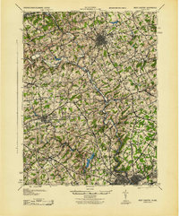
1943 Map of West Chester
USGS Topo · Published 1943About this map
West Chester serves as the focal point of this 1943 War Department survey, showing the borough's dense street grid surrounded by the productive landscapes of Chester and Delaware Counties. The region is defined by its complex waterway network, specifically the winding paths of Brandywine Creek and its branches, which once powered local industry at sites like Dutton Mill. This map captures a critical period of infrastructure, documenting the heavy presence of the Pennsylvania and Reading railroads as they linked established settlements like Downingtown and Kennett Square to the Philadelphia corridor.
Find a feature on this map
110 named features on this map. Tap any name to fly to it.
Don’t see what you’re looking for? This feature index may not catch every label — zoom into the map to look around manually.
Map Details
Editions of this 1943 West Chester Map
This is the sole edition of this map. No revisions or reprints were ever made.
Other maps of this area

1890 · Salem
USGS Topo · 1:62,500

1894 · Chester
USGS Topo · 1:62,500

1894 · Norristown
USGS Topo · 1:62,500

1895 · Norristown
USGS Topo · 1:62,500

1896 · Norristown
USGS Topo · 1:62,500

1896 · Chester
USGS Topo · 1:62,500

1898 · Salem
USGS Topo · 1:62,500

1898 · Elkton
USGS Topo · 1:62,500

1898 · Chester
USGS Topo · 1:62,500

1900 · Elkton
USGS Topo · 1:62,500