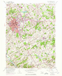
1954 Map of West Chester
USGS Topo · Published 1975About this map
West Chester serves as the focal point of this mid-century portrait, showing the borough's growth outward into West Goshen and East Bradford. The landscape is a mix of academic institutions and historical preservation, with the State Teachers College anchoring the town center while Brandywine Battlefield State Park protects the southern reaches along Brandywine Creek. Educational and social history is visible in the placement of the Glen Mills Sch, Westtown Sch, and the Dante Orphanage, reflecting the region's long-standing role as a center for institutional and parochial land use.
Find a feature on this map
82 named features on this map. Tap any name to fly to it.
Don’t see what you’re looking for? This feature index may not catch every label — zoom into the map to look around manually.
Map Details
Editions of this 1954 West Chester Map
4 editions found
Other maps of this area

1894 · Chester
USGS Topo · 1:62,500

1894 · Norristown
USGS Topo · 1:62,500

1895 · Norristown
USGS Topo · 1:62,500

1896 · Norristown
USGS Topo · 1:62,500

1896 · Chester
USGS Topo · 1:62,500

1898 · Chester
USGS Topo · 1:62,500

1901 · Camden
USGS Topo · 1:125,000

1901 · West Chester
USGS Topo · 1:62,500

1904 · West Chester
USGS Topo · 1:62,500

1906 · Phoenixville
USGS Topo · 1:62,500
Featured Places
- West Goshen Township, PA
- West Chester, PA
- Willistown Township, PA
- Westtown, Thornbury Township
- Birmingham Township, PA