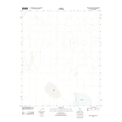
2012 Map of West Cronise Lake
USGS Topo · Published 2012About this map
West Cronise Lake and East Cronise Lake dominate the lower half of this San Bernardino County landscape. These ephemeral basins, characteristic of the arid interior, are captured during a period of detailed digital surveying by the U.S. Geological Survey. The map shows the stark hydrography of the region, where numerous dry washes and intermittent drainage patterns descend toward the lake beds. Human presence is limited to the single passage of Cronise Lake Rd, which skirts the eastern edge of the lower basin, reflecting the sparse infrastructure in this part of the California desert during the early twenty-first century.
Find a feature on this map
3 named features on this map. Tap any name to fly to it.
Don’t see what you’re looking for? This feature index may not catch every label — zoom into the map to look around manually.
Map Details
Editions of this 2012 West Cronise Lake Map
This is the sole edition of this map. No revisions or reprints were ever made.
Other maps of this area

1933 · Avawatz Mountains
USGS Topo · 1:250,000

1947 · Trona
USGS Topo · 1:250,000

1948 · Red Pass Lake
USGS Topo · 1:62,500

1948 · Trona
USGS Topo · 1:250,000

1948 · Cave Mountain
USGS Topo · 1:62,500

1951 · Cave Mountain
USGS Topo · 1:62,500

1951 · Red Pass Lake
USGS Topo · 1:62,500

1953 · Trona
USGS Topo · 1:250,000
1956 · Soda Lake
USGS Topo · 1:62,500

1956 · Baker
USGS Topo · 1:62,500