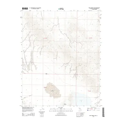
2015 Map of West Cronise Lake
USGS Topo · Published 2015About this map
West Cronise Lake and E Cronise Lake anchor the southern portion of this landscape, sitting at the base of the Cronise Mountains. Located in a central stretch of the Mojave Desert, the map illustrates a stark terminal drainage basin where seasonal water and sediment patterns define the geography. The terrain is characterized by the complex alluvial fan structures descending from the northern heights into the dry lake beds, revealing the natural hydrology of San Bernardino County before modern interventions. The stark division between the high mountain contours and the flat lake basins provides a clear look at the geological forces shaping the California desert during this mid-2010s survey.
Find a feature on this map
8 named features on this map. Tap any name to fly to it.
Don’t see what you’re looking for? This feature index may not catch every label — zoom into the map to look around manually.
Map Details
Editions of this 2015 West Cronise Lake Map
This is the sole edition of this map. No revisions or reprints were ever made.
Other maps of this area

1933 · Avawatz Mountains
USGS Topo · 1:250,000

1947 · Trona
USGS Topo · 1:250,000

1948 · Red Pass Lake
USGS Topo · 1:62,500

1948 · Trona
USGS Topo · 1:250,000

1948 · Cave Mountain
USGS Topo · 1:62,500

1951 · Cave Mountain
USGS Topo · 1:62,500

1951 · Red Pass Lake
USGS Topo · 1:62,500

1953 · Trona
USGS Topo · 1:250,000
1956 · Soda Lake
USGS Topo · 1:62,500

1956 · Baker
USGS Topo · 1:62,500