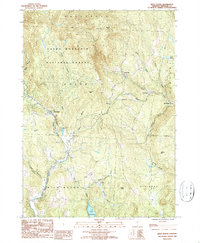
1986 Map of West Dover
USGS Topo · Published 1987About this map
The Green Mountain National Forest dominates the high terrain of Windham County, where the Deerfield River and its North Branch Deerfield River carve through the narrow valleys of southern Vermont. This 1980s topographic study captures a landscape defined by small clusters of settlement such as West Dover and East Dover, alongside smaller locales like Goose City and Brookside. High peaks including Rice Hill and Cooper Hill overlook a network of mountain streams like Blue Brook and Negus Brook. To the south, Lake Raponda serves as a prominent water feature at the edge of the Wilmington boundary. The map also records mid-century infrastructure like the Mt Snow Airport, illustrating the balance between traditional timberland and the emerging recreation economy of the late 20th century.
Find a feature on this map
36 named features on this map. Tap any name to fly to it.
Don’t see what you’re looking for? This feature index may not catch every label — zoom into the map to look around manually.
Map Details
Editions of this 1986 West Dover Map
This is the sole edition of this map. No revisions or reprints were ever made.
Other maps of this area

1889 · Wilmington
USGS Topo · 1:62,500

1891 · Wilmington
USGS Topo · 1:62,500

1891 · Brattleboro
USGS Topo · 1:62,500

1893 · Brattleboro
USGS Topo · 1:62,500

1894 · Londonderry
USGS Topo · 1:62,500

1899 · Londonderry
USGS Topo · 1:62,500

1899 · Wilmington
USGS Topo · 1:62,500

1930 · Saxtons River
USGS Topo · 1:48,000

1932 · Brattleboro
USGS Topo · 1:48,000

1933 · Saxtons River
USGS Topo · 1:62,500