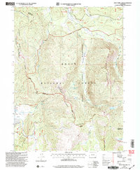
2000 Map of West Fork Lake
USGS Topo · Published 2004About this map
The Continental Divide winds through this high-altitude landscape in Routt National Forest, where the complex drainage systems of the Sierra Madre and Mount Zirkel range define the terrain. At the turn of the millennium, this area remained largely defined by its natural water features and long-distance travel routes. The Hog Park Guard Station stands as a rare human outpost near the northern boundary, while numerous water bodies like West Fork Lake, Manzanares Lake, and the Sanders Lakes are scattered across the alpine basins. The map illustrates a dense network of high-country paths, including the Hahns Peak-Bears Ears National Scenic Trail and the Wyoming Trail, which follow the ridgelines and creek valleys. This survey documents the intersection of multiple drainage basins, such as the West Fork Encampment River and Little Big Red Creek, providing a detailed look at the hydrology before these headwaters join larger river systems.
Find a feature on this map
26 named features on this map. Tap any name to fly to it.
Don’t see what you’re looking for? This feature index may not catch every label — zoom into the map to look around manually.
Map Details
Editions of this 2000 West Fork Lake Map
This is the sole edition of this map. No revisions or reprints were ever made.
Other maps of this area

1911 · Hahns Peak
USGS Topo · 1:125,000

1913 · Hahns Peak
USGS Topo · 1:125,000

1939 · Saratoga
USGS Topo · 1:125,000

1954 · Rawlins
USGS Topo · 1:250,000

1954 · Craig
USGS Topo · 1:250,000

1955 · Davis Peak
USGS Topo · 1:24,000

1955 · Mount Zirkel
USGS Topo · 1:24,000

1956 · Pearl
USGS Topo · 1:62,500

1957 · Craig
USGS Topo · 1:250,000

1958 · Rawlins
USGS Topo · 1:250,000