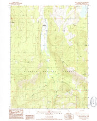
1986 Map of West Haight Mtn
USGS Topo · Published 1986About this map
Mt Shasta Woods occupies a central valley corridor within this 1980s topographic study of the Klamath National Forest. The landscape is defined by its significant hydrography, with numerous water sources such as Rose Spring, Double Spring, and Onion Spring feeding into the drainage basins of Butte Creek and Pomeroy Creek. Elevated terrain anchors the map, notably Deer Mountain in the northwest and West Haight Mtn near the eastern boundary, separated by the Divide. The network of unimproved roads and four-wheel-drive trails suggests a region managed for timber and forest access rather than dense residential development, centered around the Butte and the steep descent of Blue Canyon.
Find a feature on this map
21 named features on this map. Tap any name to fly to it.
Don’t see what you’re looking for? This feature index may not catch every label — zoom into the map to look around manually.
Map Details
Editions of this 1986 West Haight Mtn Map
This is the sole edition of this map. No revisions or reprints were ever made.
Other maps of this area

1886 · Modoc Lava Bed
USGS Topo · 1:250,000

1886 · Shasta
USGS Topo · 1:250,000

1892 · Modoc Lava-Bed
USGS Topo · 1:250,000

1894 · Shasta
USGS Topo · 1:250,000

1932 · Bartle
USGS Topo · 1:96,000

1934 · Macdoel
USGS Topo · 1:96,000

1935 · Dunsmuir
USGS Topo · 1:125,000

1939 · Bartle
USGS Topo · 1:125,000

1941 · Macdoel
USGS Topo · 1:125,000

1948 · Weed
USGS Topo · 1:250,000