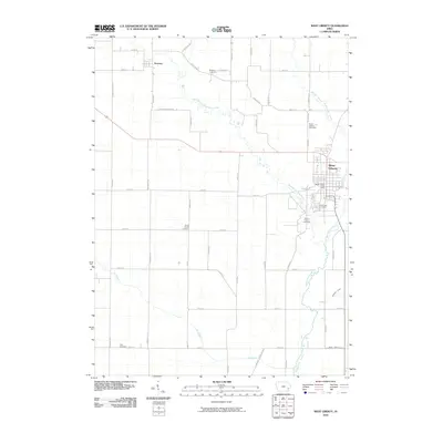
2010 Map of West Liberty
USGS Topo · Published 2010About this map
The Muscatine County township of West Liberty sits at the heart of this landscape, its structured grid contrasting with the winding paths of Wapsinonoc Creek and its tributaries. As a regional hub, it contains the West Liberty Post Office and several significant burial grounds, including Oak Ridge Cemetery and Mount Calvary Cemetery. The surrounding agricultural countryside is defined by the three branches of the Wapsinonoc — the West Branch, Middle Branch, and main stream — which drain the prairie toward the southeast. To the northwest, the smaller settlement of Downey marks a secondary cluster of activity near its namesake Downey Cemetery. This 2010 survey illustrates the persistent rural character of eastern Iowa, where a dense network of avenues and streets connects scattered family-named landmarks like Lenz Cemetery and South Prairie Cemetery across the lowlands of Big Slough.
Find a feature on this map
47 named features on this map. Tap any name to fly to it.
Don’t see what you’re looking for? This feature index may not catch every label — zoom into the map to look around manually.
Map Details
Editions of this 2010 West Liberty Map
This is the sole edition of this map. No revisions or reprints were ever made.
Other maps of this area

1891 · Wilton Junction
USGS Topo · 1:62,500

1894 · West Liberty
USGS Topo · 1:62,500

1901 · Stanwood
USGS Topo · 1:125,000

1948 · Muscatine
USGS Topo · 1:62,500

1958 · Davenport
USGS Topo · 1:250,000

1961 · Davenport
USGS Topo · 1:250,000

1962 · Davenport
USGS Topo · 1:250,000
1965 · West Liberty
USGS Topo · 1:24,000
1965 · Muscatine NW
USGS Topo · 1:24,000
1965 · Atalissa
USGS Topo · 1:24,000