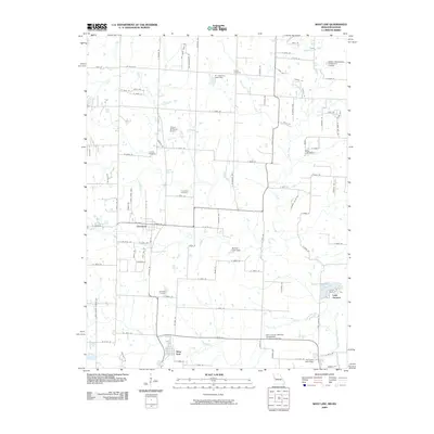
2009 Map of West Line
USGS Topo · Published 2009About this map
Cleveland and West Line anchor this residential and agricultural corridor in western Missouri, just as the regional landscape was transitioning toward suburban expansion in the late 2000s. The map reveals a high density of rural burial grounds, including Glenwild Cemetery, Corinth Cemetery, Cleveland Cemetery, and Frazee Cemetery, providing a wealth of information for genealogical research in this part of Cass County. Water management is a defining feature of the area, characterized by numerous small impoundments such as Al Jurgeson Lake Dam, Wells Lake Dam, and Bartlett Lake Dam situated along tributaries like Massey Creek and East Creek. To the southeast, the residential cluster of Lake Annette sits near the banks of the South Grand River, while the Flying M Ranch Airport serves as a distinct local landmark among the grid of township roads. The map also documents essential infrastructure, such as the Belton Wastewater Treatment Facility and the Cass County Midway Wastewater Treatment Facility.
Find a feature on this map
103 named features on this map. Tap any name to fly to it.
Don’t see what you’re looking for? This feature index may not catch every label — zoom into the map to look around manually.
Map Details
Editions of this 2009 West Line Map
This is the sole edition of this map. No revisions or reprints were ever made.
Other maps of this area

1887 · Harrisonville
USGS Topo · 1:125,000

1887 · Olathe
USGS Topo · 1:125,000

1892 · Harrisonville
USGS Topo · 1:125,000

1893 · Olathe
USGS Topo · 1:125,000

1894 · Harrisonville
USGS Topo · 1:125,000

1947 · Lawrence
USGS Topo · 1:250,000

1950 · Lawrence
USGS Topo · 1:250,000
1953 · Belton
USGS Topo · 1:24,000

1953 · Freeman
USGS Topo · 1:24,000

1953 · West Line
USGS Topo · 1:24,000