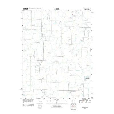
2011 Map of West Line
USGS Topo · Published 2011About this map
Cleveland and West Line anchor this rural landscape in Cass County, where the transition from agricultural land to small-town settlement is clearly defined. The terrain is marked by a network of local waterways, including the South Grand River and Poney Creek, which feed into several private and community reservoirs like Lake Annette and Kurzweil Lake. For local historians and genealogists, the map provides a precise record of several family and community burial grounds, such as Glenwild Cemetery, Corinth Cemetery, Frazee Cemetery, and the Cleveland Cemetery.
Find a feature on this map
85 named features on this map. Tap any name to fly to it.
Don’t see what you’re looking for? This feature index may not catch every label — zoom into the map to look around manually.
Map Details
Editions of this 2011 West Line Map
This is the sole edition of this map. No revisions or reprints were ever made.
Other maps of this area

1887 · Harrisonville
USGS Topo · 1:125,000

1887 · Olathe
USGS Topo · 1:125,000

1892 · Harrisonville
USGS Topo · 1:125,000

1893 · Olathe
USGS Topo · 1:125,000

1894 · Harrisonville
USGS Topo · 1:125,000

1947 · Lawrence
USGS Topo · 1:250,000

1950 · Lawrence
USGS Topo · 1:250,000
1953 · Belton
USGS Topo · 1:24,000

1953 · Freeman
USGS Topo · 1:24,000

1953 · West Line
USGS Topo · 1:24,000