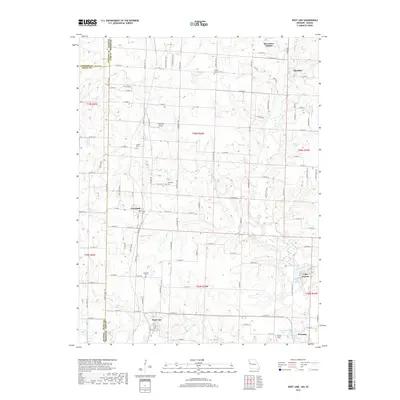
2017 Map of West Line
USGS Topo · Published 2017About this map
State Line Road serves as the dividing line between Missouri and Kansas, splitting this rural landscape where Cass County meets Johnson and Miami Counties. The settlement pattern is anchored by small towns and unincorporated communities like Cleveland, West Line, and Freeman, with the western edge of Peculiar appearing in the northeast corner. Historically significant sites for genealogists include several well-distributed burial grounds such as Glenwild Cemetery, Corinth Cemetery, and Frazee Cemetery, which speak to the long-established farming communities in the area.
Find a feature on this map
108 named features on this map. Tap any name to fly to it.
Don’t see what you’re looking for? This feature index may not catch every label — zoom into the map to look around manually.
Map Details
Editions of this 2017 West Line Map
This is the sole edition of this map. No revisions or reprints were ever made.
Other maps of this area

1887 · Harrisonville
USGS Topo · 1:125,000

1887 · Olathe
USGS Topo · 1:125,000

1892 · Harrisonville
USGS Topo · 1:125,000

1893 · Olathe
USGS Topo · 1:125,000

1894 · Harrisonville
USGS Topo · 1:125,000

1947 · Lawrence
USGS Topo · 1:250,000

1950 · Lawrence
USGS Topo · 1:250,000
1953 · Belton
USGS Topo · 1:24,000

1953 · Freeman
USGS Topo · 1:24,000

1953 · West Line
USGS Topo · 1:24,000